Tracking seals from outer space
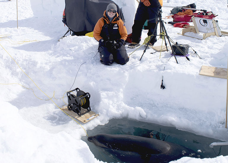
Shanelle Dyer is an MSc Geography student at the University of Canterbury, using remote sensing and GIS for conservation. Her thesis focuses on counting Weddell seals in the Ross Sea Marine Protected Area (MPA) in Antarctica, in an effort to see how well MPAs protect our vulnerable marine life.
On this page
Shanelle Dyer photographing a Weddell seal, Ross Sea, Antarctica
Ms Dyer’s main concern is whether the toothfish fishing industry in the Ross Sea has had an impact on top predators, such as Weddell seals, who rely on toothfish as a major food source. To find out, she set about counting the seals and monitoring their increases and declines in populations using remote camera and satellite images processed with the help of computer algorithms.
Problems with counting
Traditionally, seals are monitored by someone walking around physically counting them. Often this is combined with manual counts from photos, and more recently, from satellite images. However, with such high numbers of seals, it isn’t feasible to have people constantly walking around and hand counting.
The other problem with this method is it only provides information from a specific time and location, whereas Weddell seals are often moving around, going diving, and ‘hauling-out’. (When they haul themselves back onto land or the sea ice to rest and reproduce between hunting for food.)
All these reasons make it difficult to get a quick and accurate count.
Space-based technology
Ms Dyer’s research combines GIS technology, remote sensing, and artificial intelligence to count the seals from afar and better analyse their haul-out patterns.
It involves taking images every ten minutes over most of a summer season — typically a few months. At the end of the season, a computer algorithm, which has been programmed to detect seals in the field camera images, provides accurate counts. These are analysed against satellite images to determine whether the visible seals are representative of the actual population.
A season can produce a minimum of 40,000 images, which would be impossible to count manually. With Ms Dyer’s methodology, this can all be done in a few days and provide really useful and accurate data.
“This approach is incredibly beneficial as the algorithm can improve its detection capabilities the more data it has; so different seasons, locations, and image types can all be processed to provide us with more information. When all of these are combined, we can get the best understanding of seal numbers,” says Ms Dyer.
As space technology progresses, the data we collect improves and the questions we can answer increases, so in conservation more species can be studied and protected without disturbing them.
What it means for New Zealand
Ms Dyer sees the use of space borne data with neural networks such as algorithms to be endless — from conservation, urban development, forestry, natural disasters and meteorology to deep space exploration.
She feels it’s important to find solutions to scientific problems that reduce human impacts on the environment, produce accurate and useful data, and are economically viable.
New Zealand is in an ideal position to really harness aerospace and computing technologies since we already have some of the leading people in these fields right here.
“We have rare and endemic species that we want to protect. We also have a unique and highly dynamic environment which allows for key impacts of global warming to be studied. The potential for more jobs in these and similar fields is huge because there is always a need to improve data collection platforms and sensors.”
New Zealand needs the systems and software to process data — our vulnerable wildlife and ecosystems provide us with a very good reason to do so.